
-

- Lou's Kiteboarding home page
-

- Lou's Comedy home page
|
|
|---|
Find the Best Conditions For enjoyable and safe riding, look for steady, side-on-shore winds, most easily found on the coasts. Our Weather page contains a lot of links. Where's the best wind? Here is a list by month of best wind for kiteboarding destinations worldwide.
Here in the US check out the average temperatures.
Worldwide
COGOW maps give you a good idea of when and where the wind blows. (Use Google Chrome)

 Click and zoom anywhere on the earth for current/past/forecast graphic of wind & other WX information.
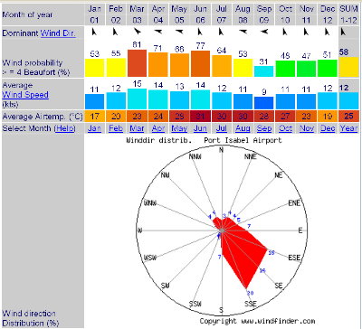
Get averages by month for: winds, probabilities, directions, temperatures and lots more at WindFinder.com (Pigeon Point, Tobago here).
 .
.
Wind Alert gives the year at a glance, graphically, almost anywhere.(Cabarete here).
Averages by month of everything but wind at Holiday Weather (Cabarete here).
 .
.
|
10 min Video Excelent kiteboarding on The Outer Banks from The Weather Channel Yes, we know many of the people and have ridden all the places in this video. |
| " |
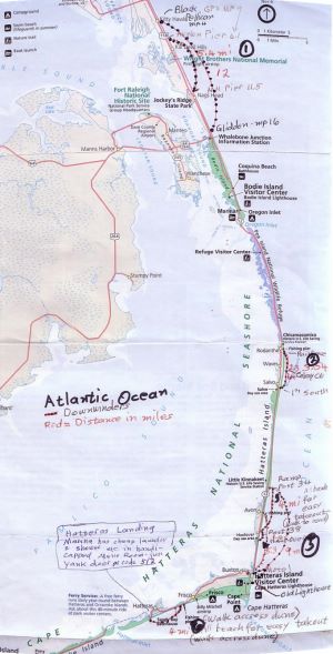
ha...). This includes the famous Hatters Island, just south of Kitty Hawk, North Carolina where the Wright Brothers conducted their first flight in 1903. In fact their memorial is a good place to spend the day if the wind is not blowing or is blowing too much for your kite size and skill level.
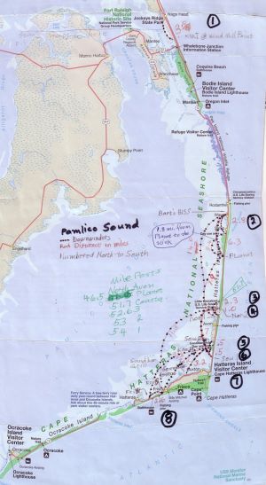
Mile Post Index: Finding things on the Outer Banks can be a challenge. It's like taking your typical town and stretching it out in one long street. Everything is along there somewhere, but where? In the northern area (Kitty Hawk, Kill Devil Hills, Nags Head) they reference mile posts. Here is our own Mile Post Index of the good stuff. Your GPS distance from HAMILE will be your exact mile-post location on the Croatian Highway
Two ways to create the HAMILE waypoint are:
1) Download our GPS waypoints and look for HAMILE
2) In your GPS receiver create a HAMILE waypoint at N36.12266 W75.72458
Most awesome flat-water downwinder, anywhere. 6.5 miles of pure fun on an OBX southwest wind from Planet of the Apes to Kitty Hawk Kites in Waves (my waypoints haPlan to haKHK) Most places you can stand up in the water!
RealSlick - another good one
OBX Riding Locations and Downwinder Maps by Arizona Lou
| Pamlico Sound | Atlantic Ocean | ||
|---|---|---|---|
| (Broadband Version) | (Broadband Version) | ||
 |
 |
Right click a map and Save Image As... to download it to your computer. |
|
One of our higher on-camera jumps; Laguna Madre, SPI, TX;
Photo by George Pope |
|
South Padre Island, Texas (Look for our GPS waypoints beginning with Sp...
)
| Tiago Amaud's ultimate selfie; location, unknown |
Puerto Penasco (Rocky Point) Mexico (Look for our GPS waypoints beginning with Mxr...
)
Here is an EXCELLENT interactive map that Tommy "Thomas" put together with about 50 locations for kiting, places to stay, eat and drink. He and Rita are good people to know down there. go 2 Rocky Point.com is Tommy & Rita's website
|
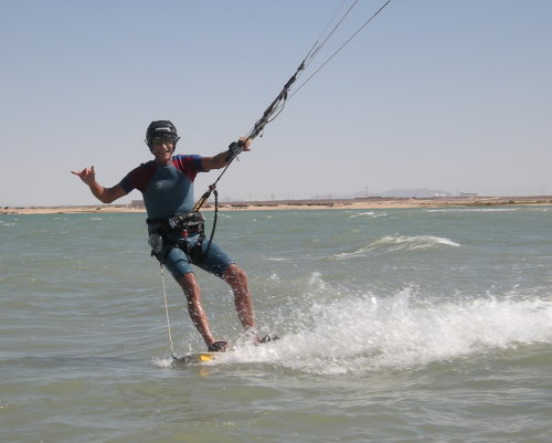
Cholla Bay, Puerto Penasco (Rocky Point), Mexico usable only @ high tide. Arizona Lou
Photo by Roberto Buck |
|
San Carlos, Mexico (on the mainland). (Look for our GPS waypoints beginning with Mxs...
)
|
3:09 min Brazil: Cumbuco to Cauipe; Kite Adventures, taken by a camera on the kite |
| " |
Brazil (Look for our GPS waypoints beginning with b...
) . Check out the historical winds by month in Northeastern Brazil, courtesy of Oregon State University.
GPS Waypoints & Coordinates for kiteboarding locations & shops (over 200 from Arizona Lou) in the following file formats:
.txt file (text) - Read/Search/Copy/Paste/Coordinates (1.3 Mb file)
.gdb file (Garmin specific) - Open with your software or load into your GPS receiver (346 Kb file)
.gpx file (GPS Exchange Format) - Copy & paste into a file that is compatable with Google Earth & most brands of GPS receivers & software (2.2 Mb file)